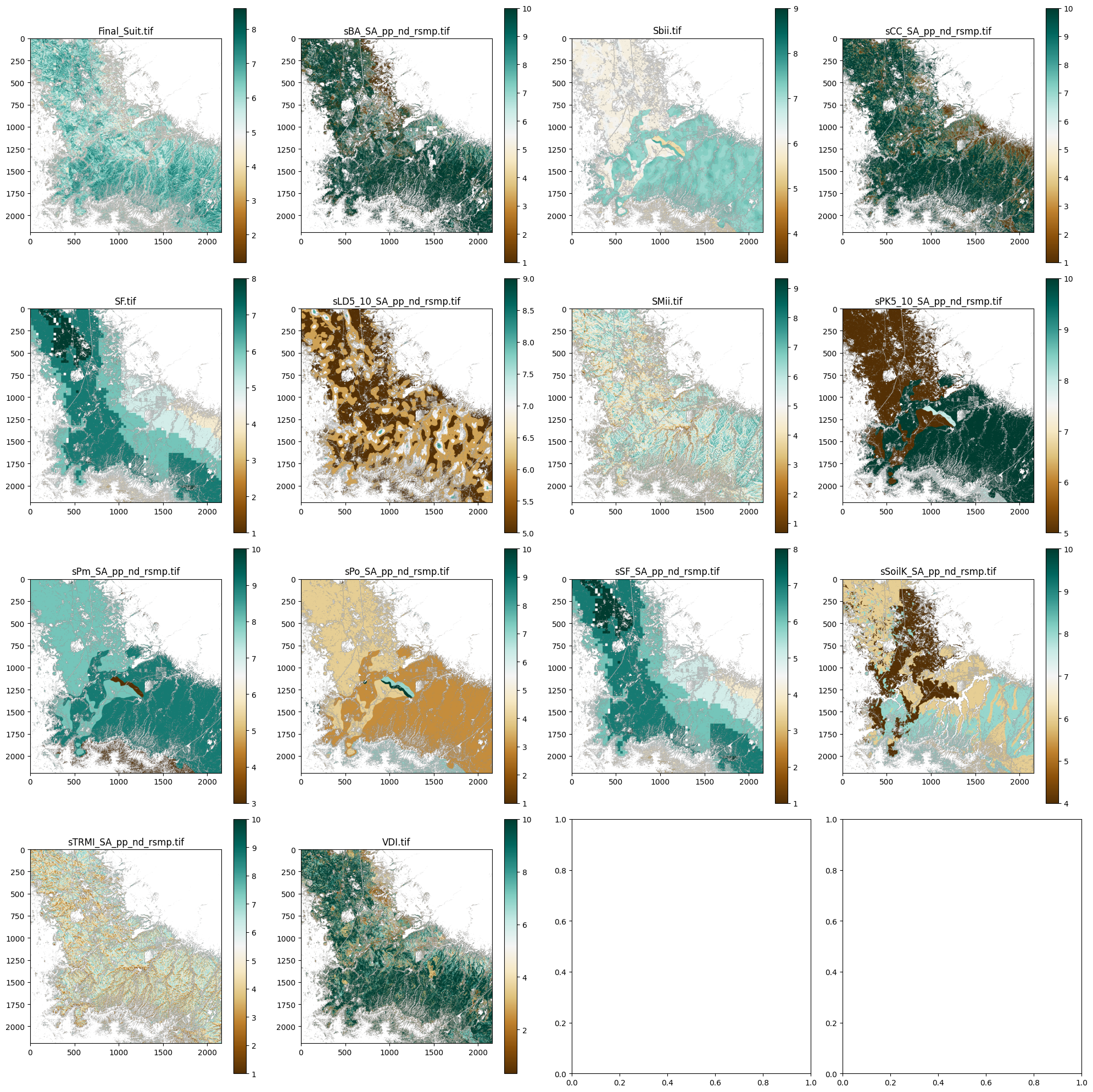
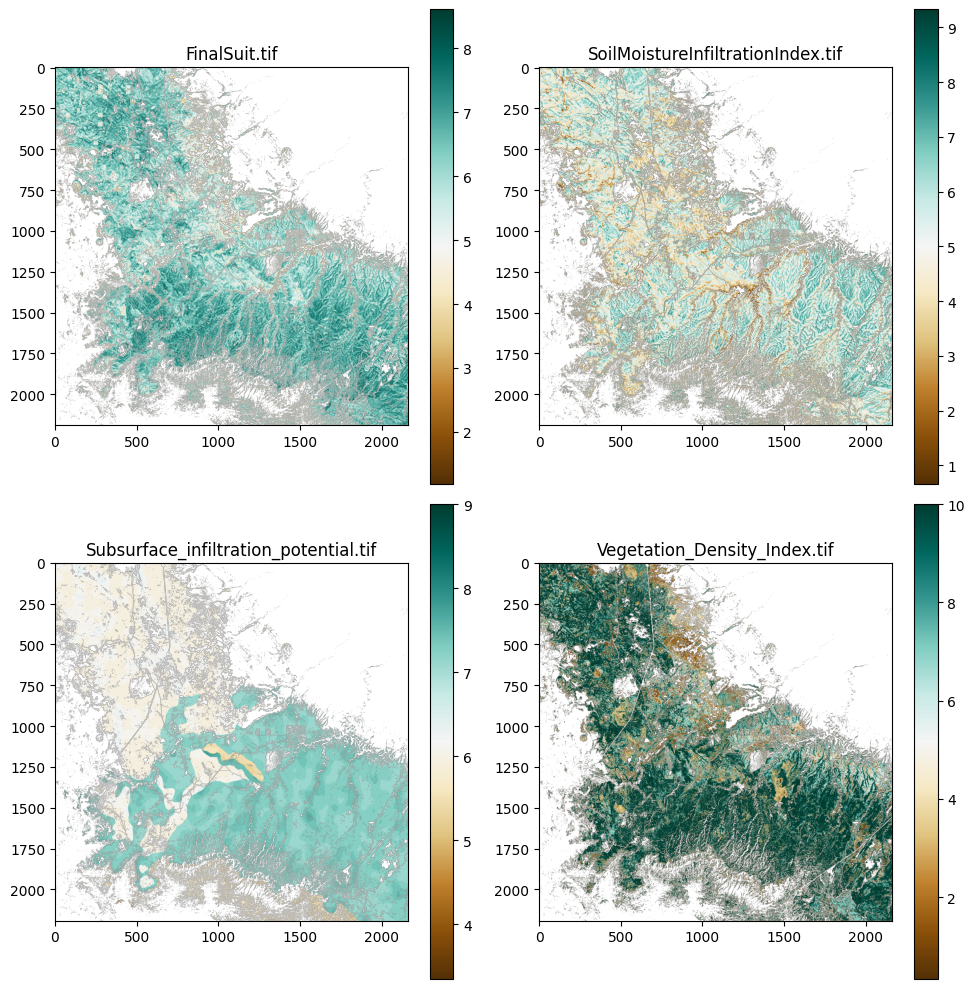
{'File': 'Final_Suit.tif', 'Filepath': 'G:\\Data\\Thinning_Recharge_Final_Data\\SA\\resampled\\Final_Suit.tif', 'Projection': CRS.from_wkt('PROJCS["NAD83(2011) / UTM zone 12N",GEOGCS["NAD83(2011)",DATUM["NAD83_National_Spatial_Reference_System_2011",SPHEROID["GRS 1980",6378137,298.257222101,AUTHORITY["EPSG","7019"]],AUTHORITY["EPSG","1116"]],PRIMEM["Greenwich",0,AUTHORITY["EPSG","8901"]],UNIT["degree",0.0174532925199433,AUTHORITY["EPSG","9122"]],AUTHORITY["EPSG","6318"]],PROJECTION["Transverse_Mercator"],PARAMETER["latitude_of_origin",0],PARAMETER["central_meridian",-111],PARAMETER["scale_factor",0.9996],PARAMETER["false_easting",500000],PARAMETER["false_northing",0],UNIT["metre",1,AUTHORITY["EPSG","9001"]],AXIS["Easting",EAST],AXIS["Northing",NORTH],AUTHORITY["EPSG","6341"]]'), 'Min Value': np.float32(1.1899999), 'Max Value': np.float32(8.61336), 'Mean Value': np.float32(5.9957256), 'Extent': BoundingBox(left=445653.43769999966, bottom=3798617.068499999, right=510453.43769999966, top=3864347.068499999), 'Width': 2160, 'Height': 2191, 'Dimensions': (2191, 2160), 'Data Type': 'float32'}
{'File': 'sBA_SA_pp_nd_rsmp.tif', 'Filepath': 'G:\\Data\\Thinning_Recharge_Final_Data\\SA\\resampled\\sBA_SA_pp_nd_rsmp.tif', 'Projection': CRS.from_wkt('PROJCS["NAD83(2011) / UTM zone 12N",GEOGCS["NAD83(2011)",DATUM["NAD83_National_Spatial_Reference_System_2011",SPHEROID["GRS 1980",6378137,298.257222101,AUTHORITY["EPSG","7019"]],AUTHORITY["EPSG","1116"]],PRIMEM["Greenwich",0,AUTHORITY["EPSG","8901"]],UNIT["degree",0.0174532925199433,AUTHORITY["EPSG","9122"]],AUTHORITY["EPSG","6318"]],PROJECTION["Transverse_Mercator"],PARAMETER["latitude_of_origin",0],PARAMETER["central_meridian",-111],PARAMETER["scale_factor",0.9996],PARAMETER["false_easting",500000],PARAMETER["false_northing",0],UNIT["metre",1,AUTHORITY["EPSG","9001"]],AXIS["Easting",EAST],AXIS["Northing",NORTH],AUTHORITY["EPSG","6341"]]'), 'Min Value': np.float32(1.0), 'Max Value': np.float32(10.0), 'Mean Value': np.float32(7.940568), 'Extent': BoundingBox(left=445653.43769999966, bottom=3798617.068499999, right=510453.43769999966, top=3864347.068499999), 'Width': 2160, 'Height': 2191, 'Dimensions': (2191, 2160), 'Data Type': 'float32'}
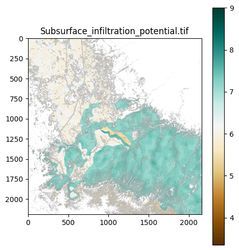
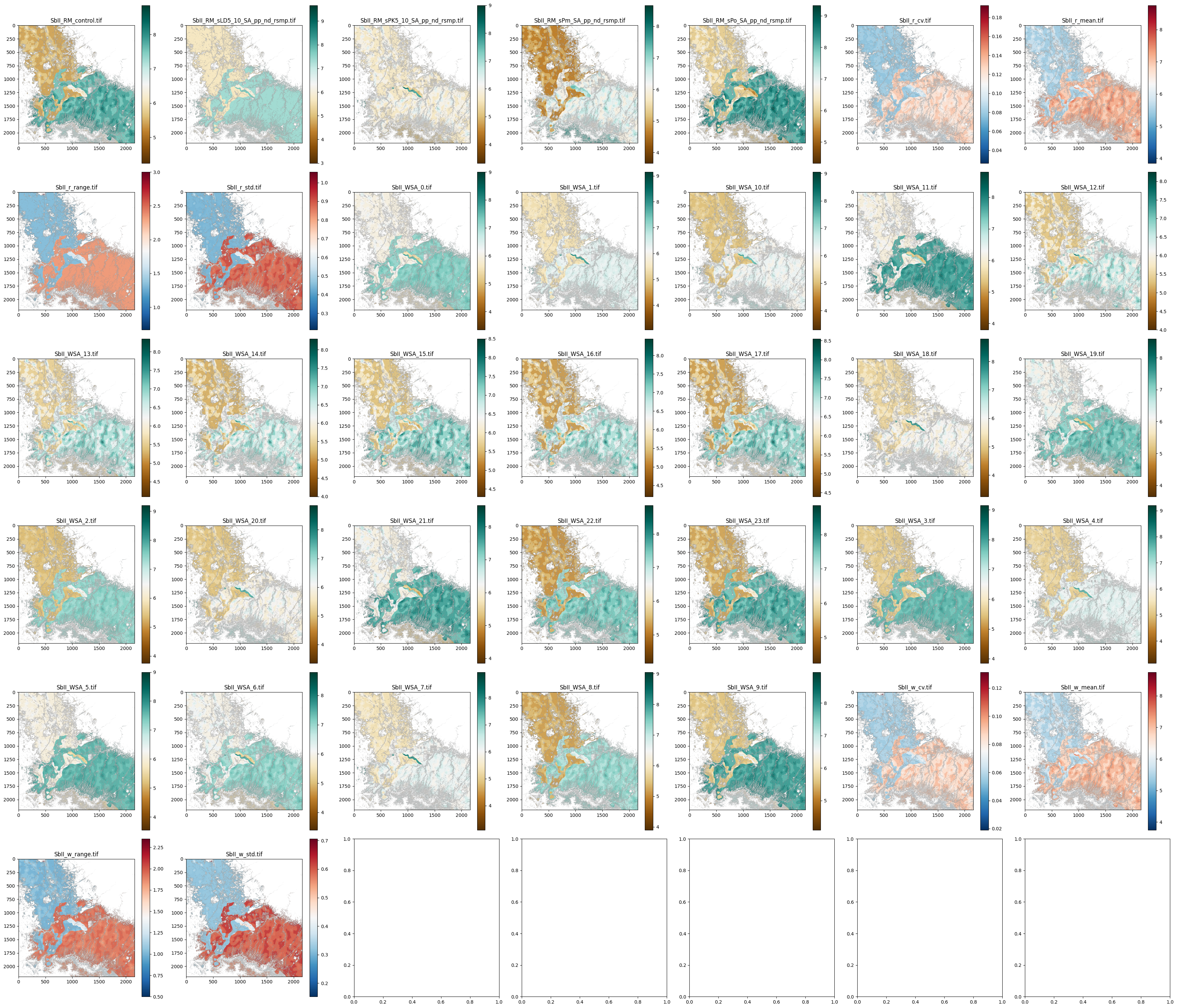
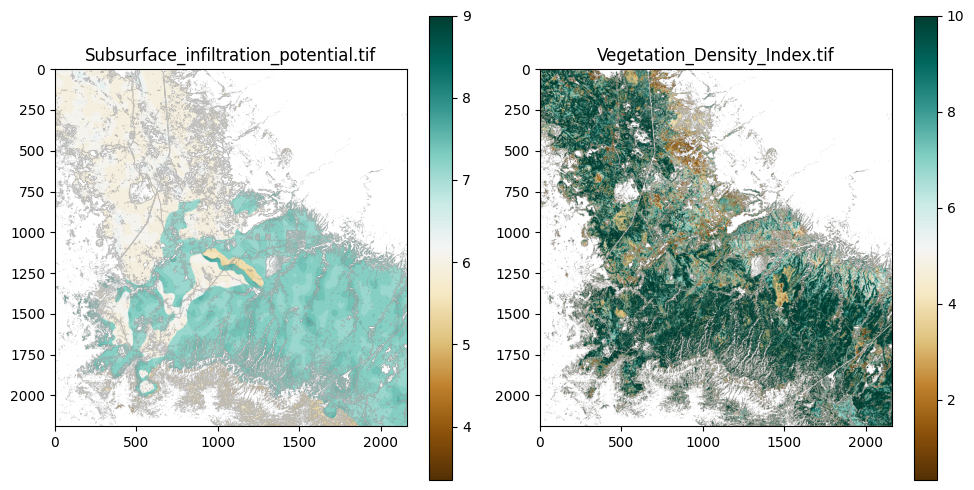
{'File': 'Sbii.tif', 'Filepath': 'G:\\Data\\Thinning_Recharge_Final_Data\\SA\\resampled\\Sbii.tif', 'Projection': CRS.from_wkt('PROJCS["NAD83(2011) / UTM zone 12N",GEOGCS["NAD83(2011)",DATUM["NAD83_National_Spatial_Reference_System_2011",SPHEROID["GRS 1980",6378137,298.257222101,AUTHORITY["EPSG","7019"]],AUTHORITY["EPSG","1116"]],PRIMEM["Greenwich",0,AUTHORITY["EPSG","8901"]],UNIT["degree",0.0174532925199433,AUTHORITY["EPSG","9122"]],AUTHORITY["EPSG","6318"]],PROJECTION["Transverse_Mercator"],PARAMETER["latitude_of_origin",0],PARAMETER["central_meridian",-111],PARAMETER["scale_factor",0.9996],PARAMETER["false_easting",500000],PARAMETER["false_northing",0],UNIT["metre",1,AUTHORITY["EPSG","9001"]],AXIS["Easting",EAST],AXIS["Northing",NORTH],AUTHORITY["EPSG","6341"]]'), 'Min Value': np.float32(3.3500001), 'Max Value': np.float32(9.0), 'Mean Value': np.float32(6.6547184), 'Extent': BoundingBox(left=445653.43769999966, bottom=3798617.068499999, right=510453.43769999966, top=3864347.068499999), 'Width': 2160, 'Height': 2191, 'Dimensions': (2191, 2160), 'Data Type': 'float32'}
{'File': 'sCC_SA_pp_nd_rsmp.tif', 'Filepath': 'G:\\Data\\Thinning_Recharge_Final_Data\\SA\\resampled\\sCC_SA_pp_nd_rsmp.tif', 'Projection': CRS.from_wkt('PROJCS["NAD83(2011) / UTM zone 12N",GEOGCS["NAD83(2011)",DATUM["NAD83_National_Spatial_Reference_System_2011",SPHEROID["GRS 1980",6378137,298.257222101,AUTHORITY["EPSG","7019"]],AUTHORITY["EPSG","1116"]],PRIMEM["Greenwich",0,AUTHORITY["EPSG","8901"]],UNIT["degree",0.0174532925199433,AUTHORITY["EPSG","9122"]],AUTHORITY["EPSG","6318"]],PROJECTION["Transverse_Mercator"],PARAMETER["latitude_of_origin",0],PARAMETER["central_meridian",-111],PARAMETER["scale_factor",0.9996],PARAMETER["false_easting",500000],PARAMETER["false_northing",0],UNIT["metre",1,AUTHORITY["EPSG","9001"]],AXIS["Easting",EAST],AXIS["Northing",NORTH],AUTHORITY["EPSG","6341"]]'), 'Min Value': np.float32(1.0), 'Max Value': np.float32(10.0), 'Mean Value': np.float32(7.8302107), 'Extent': BoundingBox(left=445653.43769999966, bottom=3798617.068499999, right=510453.43769999966, top=3864347.068499999), 'Width': 2160, 'Height': 2191, 'Dimensions': (2191, 2160), 'Data Type': 'float32'}
{'File': 'SF.tif', 'Filepath': 'G:\\Data\\Thinning_Recharge_Final_Data\\SA\\resampled\\SF.tif', 'Projection': CRS.from_wkt('PROJCS["NAD83(2011) / UTM zone 12N",GEOGCS["NAD83(2011)",DATUM["NAD83_National_Spatial_Reference_System_2011",SPHEROID["GRS 1980",6378137,298.257222101,AUTHORITY["EPSG","7019"]],AUTHORITY["EPSG","1116"]],PRIMEM["Greenwich",0,AUTHORITY["EPSG","8901"]],UNIT["degree",0.0174532925199433,AUTHORITY["EPSG","9122"]],AUTHORITY["EPSG","6318"]],PROJECTION["Transverse_Mercator"],PARAMETER["latitude_of_origin",0],PARAMETER["central_meridian",-111],PARAMETER["scale_factor",0.9996],PARAMETER["false_easting",500000],PARAMETER["false_northing",0],UNIT["metre",1,AUTHORITY["EPSG","9001"]],AXIS["Easting",EAST],AXIS["Northing",NORTH],AUTHORITY["EPSG","6341"]]'), 'Min Value': np.float32(1.0), 'Max Value': np.float32(8.0), 'Mean Value': np.float32(6.21031), 'Extent': BoundingBox(left=445653.43769999966, bottom=3798617.068499999, right=510453.43769999966, top=3864347.068499999), 'Width': 2160, 'Height': 2191, 'Dimensions': (2191, 2160), 'Data Type': 'float32'}
{'File': 'sLD5_10_SA_pp_nd_rsmp.tif', 'Filepath': 'G:\\Data\\Thinning_Recharge_Final_Data\\SA\\resampled\\sLD5_10_SA_pp_nd_rsmp.tif', 'Projection': CRS.from_wkt('PROJCS["NAD83(2011) / UTM zone 12N",GEOGCS["NAD83(2011)",DATUM["NAD83_National_Spatial_Reference_System_2011",SPHEROID["GRS 1980",6378137,298.257222101,AUTHORITY["EPSG","7019"]],AUTHORITY["EPSG","1116"]],PRIMEM["Greenwich",0,AUTHORITY["EPSG","8901"]],UNIT["degree",0.0174532925199433,AUTHORITY["EPSG","9122"]],AUTHORITY["EPSG","6318"]],PROJECTION["Transverse_Mercator"],PARAMETER["latitude_of_origin",0],PARAMETER["central_meridian",-111],PARAMETER["scale_factor",0.9996],PARAMETER["false_easting",500000],PARAMETER["false_northing",0],UNIT["metre",1,AUTHORITY["EPSG","9001"]],AXIS["Easting",EAST],AXIS["Northing",NORTH],AUTHORITY["EPSG","6341"]]'), 'Min Value': np.float32(5.0), 'Max Value': np.float32(9.0), 'Mean Value': np.float32(5.7170258), 'Extent': BoundingBox(left=445653.43769999966, bottom=3798617.068499999, right=510453.43769999966, top=3864347.068499999), 'Width': 2160, 'Height': 2191, 'Dimensions': (2191, 2160), 'Data Type': 'float32'}
{'File': 'SMii.tif', 'Filepath': 'G:\\Data\\Thinning_Recharge_Final_Data\\SA\\resampled\\SMii.tif', 'Projection': CRS.from_wkt('PROJCS["NAD83(2011) / UTM zone 12N",GEOGCS["NAD83(2011)",DATUM["NAD83_National_Spatial_Reference_System_2011",SPHEROID["GRS 1980",6378137,298.257222101,AUTHORITY["EPSG","7019"]],AUTHORITY["EPSG","1116"]],PRIMEM["Greenwich",0,AUTHORITY["EPSG","8901"]],UNIT["degree",0.0174532925199433,AUTHORITY["EPSG","9122"]],AUTHORITY["EPSG","6318"]],PROJECTION["Transverse_Mercator"],PARAMETER["latitude_of_origin",0],PARAMETER["central_meridian",-111],PARAMETER["scale_factor",0.9996],PARAMETER["false_easting",500000],PARAMETER["false_northing",0],UNIT["metre",1,AUTHORITY["EPSG","9001"]],AXIS["Easting",EAST],AXIS["Northing",NORTH],AUTHORITY["EPSG","6341"]]'), 'Min Value': np.float32(0.6667), 'Max Value': np.float32(9.3334), 'Mean Value': np.float32(5.0084877), 'Extent': BoundingBox(left=445653.43769999966, bottom=3798617.068499999, right=510453.43769999966, top=3864347.068499999), 'Width': 2160, 'Height': 2191, 'Dimensions': (2191, 2160), 'Data Type': 'float32'}
{'File': 'sPK5_10_SA_pp_nd_rsmp.tif', 'Filepath': 'G:\\Data\\Thinning_Recharge_Final_Data\\SA\\resampled\\sPK5_10_SA_pp_nd_rsmp.tif', 'Projection': CRS.from_wkt('PROJCS["NAD83(2011) / UTM zone 12N",GEOGCS["NAD83(2011)",DATUM["NAD83_National_Spatial_Reference_System_2011",SPHEROID["GRS 1980",6378137,298.257222101,AUTHORITY["EPSG","7019"]],AUTHORITY["EPSG","1116"]],PRIMEM["Greenwich",0,AUTHORITY["EPSG","8901"]],UNIT["degree",0.0174532925199433,AUTHORITY["EPSG","9122"]],AUTHORITY["EPSG","6318"]],PROJECTION["Transverse_Mercator"],PARAMETER["latitude_of_origin",0],PARAMETER["central_meridian",-111],PARAMETER["scale_factor",0.9996],PARAMETER["false_easting",500000],PARAMETER["false_northing",0],UNIT["metre",1,AUTHORITY["EPSG","9001"]],AXIS["Easting",EAST],AXIS["Northing",NORTH],AUTHORITY["EPSG","6341"]]'), 'Min Value': np.float32(5.0), 'Max Value': np.float32(10.0), 'Mean Value': np.float32(7.8721204), 'Extent': BoundingBox(left=445653.43769999966, bottom=3798617.068499999, right=510453.43769999966, top=3864347.068499999), 'Width': 2160, 'Height': 2191, 'Dimensions': (2191, 2160), 'Data Type': 'float32'}
{'File': 'sPm_SA_pp_nd_rsmp.tif', 'Filepath': 'G:\\Data\\Thinning_Recharge_Final_Data\\SA\\resampled\\sPm_SA_pp_nd_rsmp.tif', 'Projection': CRS.from_wkt('PROJCS["NAD83(2011) / UTM zone 12N",GEOGCS["NAD83(2011)",DATUM["NAD83_National_Spatial_Reference_System_2011",SPHEROID["GRS 1980",6378137,298.257222101,AUTHORITY["EPSG","7019"]],AUTHORITY["EPSG","1116"]],PRIMEM["Greenwich",0,AUTHORITY["EPSG","8901"]],UNIT["degree",0.0174532925199433,AUTHORITY["EPSG","9122"]],AUTHORITY["EPSG","6318"]],PROJECTION["Transverse_Mercator"],PARAMETER["latitude_of_origin",0],PARAMETER["central_meridian",-111],PARAMETER["scale_factor",0.9996],PARAMETER["false_easting",500000],PARAMETER["false_northing",0],UNIT["metre",1,AUTHORITY["EPSG","9001"]],AXIS["Easting",EAST],AXIS["Northing",NORTH],AUTHORITY["EPSG","6341"]]'), 'Min Value': np.float32(3.0), 'Max Value': np.float32(10.0), 'Mean Value': np.float32(8.262257), 'Extent': BoundingBox(left=445653.43769999966, bottom=3798617.068499999, right=510453.43769999966, top=3864347.068499999), 'Width': 2160, 'Height': 2191, 'Dimensions': (2191, 2160), 'Data Type': 'float32'}
{'File': 'sPo_SA_pp_nd_rsmp.tif', 'Filepath': 'G:\\Data\\Thinning_Recharge_Final_Data\\SA\\resampled\\sPo_SA_pp_nd_rsmp.tif', 'Projection': CRS.from_wkt('PROJCS["NAD83(2011) / UTM zone 12N",GEOGCS["NAD83(2011)",DATUM["NAD83_National_Spatial_Reference_System_2011",SPHEROID["GRS 1980",6378137,298.257222101,AUTHORITY["EPSG","7019"]],AUTHORITY["EPSG","1116"]],PRIMEM["Greenwich",0,AUTHORITY["EPSG","8901"]],UNIT["degree",0.0174532925199433,AUTHORITY["EPSG","9122"]],AUTHORITY["EPSG","6318"]],PROJECTION["Transverse_Mercator"],PARAMETER["latitude_of_origin",0],PARAMETER["central_meridian",-111],PARAMETER["scale_factor",0.9996],PARAMETER["false_easting",500000],PARAMETER["false_northing",0],UNIT["metre",1,AUTHORITY["EPSG","9001"]],AXIS["Easting",EAST],AXIS["Northing",NORTH],AUTHORITY["EPSG","6341"]]'), 'Min Value': np.float32(1.0), 'Max Value': np.float32(10.0), 'Mean Value': np.float32(3.6713552), 'Extent': BoundingBox(left=445653.43769999966, bottom=3798617.068499999, right=510453.43769999966, top=3864347.068499999), 'Width': 2160, 'Height': 2191, 'Dimensions': (2191, 2160), 'Data Type': 'float32'}
{'File': 'sSF_SA_pp_nd_rsmp.tif', 'Filepath': 'G:\\Data\\Thinning_Recharge_Final_Data\\SA\\resampled\\sSF_SA_pp_nd_rsmp.tif', 'Projection': CRS.from_wkt('PROJCS["NAD83(2011) / UTM zone 12N",GEOGCS["NAD83(2011)",DATUM["NAD83_National_Spatial_Reference_System_2011",SPHEROID["GRS 1980",6378137,298.257222101,AUTHORITY["EPSG","7019"]],AUTHORITY["EPSG","1116"]],PRIMEM["Greenwich",0,AUTHORITY["EPSG","8901"]],UNIT["degree",0.0174532925199433,AUTHORITY["EPSG","9122"]],AUTHORITY["EPSG","6318"]],PROJECTION["Transverse_Mercator"],PARAMETER["latitude_of_origin",0],PARAMETER["central_meridian",-111],PARAMETER["scale_factor",0.9996],PARAMETER["false_easting",500000],PARAMETER["false_northing",0],UNIT["metre",1,AUTHORITY["EPSG","9001"]],AXIS["Easting",EAST],AXIS["Northing",NORTH],AUTHORITY["EPSG","6341"]]'), 'Min Value': np.float32(1.0), 'Max Value': np.float32(8.0), 'Mean Value': np.float32(6.21031), 'Extent': BoundingBox(left=445653.43769999966, bottom=3798617.068499999, right=510453.43769999966, top=3864347.068499999), 'Width': 2160, 'Height': 2191, 'Dimensions': (2191, 2160), 'Data Type': 'float32'}
{'File': 'sSoilK_SA_pp_nd_rsmp.tif', 'Filepath': 'G:\\Data\\Thinning_Recharge_Final_Data\\SA\\resampled\\sSoilK_SA_pp_nd_rsmp.tif', 'Projection': CRS.from_wkt('PROJCS["NAD83(2011) / UTM zone 12N",GEOGCS["NAD83(2011)",DATUM["NAD83_National_Spatial_Reference_System_2011",SPHEROID["GRS 1980",6378137,298.257222101,AUTHORITY["EPSG","7019"]],AUTHORITY["EPSG","1116"]],PRIMEM["Greenwich",0,AUTHORITY["EPSG","8901"]],UNIT["degree",0.0174532925199433,AUTHORITY["EPSG","9122"]],AUTHORITY["EPSG","6318"]],PROJECTION["Transverse_Mercator"],PARAMETER["latitude_of_origin",0],PARAMETER["central_meridian",-111],PARAMETER["scale_factor",0.9996],PARAMETER["false_easting",500000],PARAMETER["false_northing",0],UNIT["metre",1,AUTHORITY["EPSG","9001"]],AXIS["Easting",EAST],AXIS["Northing",NORTH],AUTHORITY["EPSG","6341"]]'), 'Min Value': np.float32(4.0), 'Max Value': np.float32(10.0), 'Mean Value': np.float32(6.089721), 'Extent': BoundingBox(left=445653.43769999966, bottom=3798617.068499999, right=510453.43769999966, top=3864347.068499999), 'Width': 2160, 'Height': 2191, 'Dimensions': (2191, 2160), 'Data Type': 'float32'}
{'File': 'sTRMI_SA_pp_nd_rsmp.tif', 'Filepath': 'G:\\Data\\Thinning_Recharge_Final_Data\\SA\\resampled\\sTRMI_SA_pp_nd_rsmp.tif', 'Projection': CRS.from_wkt('PROJCS["NAD83(2011) / UTM zone 12N",GEOGCS["NAD83(2011)",DATUM["NAD83_National_Spatial_Reference_System_2011",SPHEROID["GRS 1980",6378137,298.257222101,AUTHORITY["EPSG","7019"]],AUTHORITY["EPSG","1116"]],PRIMEM["Greenwich",0,AUTHORITY["EPSG","8901"]],UNIT["degree",0.0174532925199433,AUTHORITY["EPSG","9122"]],AUTHORITY["EPSG","6318"]],PROJECTION["Transverse_Mercator"],PARAMETER["latitude_of_origin",0],PARAMETER["central_meridian",-111],PARAMETER["scale_factor",0.9996],PARAMETER["false_easting",500000],PARAMETER["false_northing",0],UNIT["metre",1,AUTHORITY["EPSG","9001"]],AXIS["Easting",EAST],AXIS["Northing",NORTH],AUTHORITY["EPSG","6341"]]'), 'Min Value': np.float32(1.0), 'Max Value': np.float32(10.0), 'Mean Value': np.float32(5.056199), 'Extent': BoundingBox(left=445653.43769999966, bottom=3798617.068499999, right=510453.43769999966, top=3864347.068499999), 'Width': 2160, 'Height': 2191, 'Dimensions': (2191, 2160), 'Data Type': 'float32'}
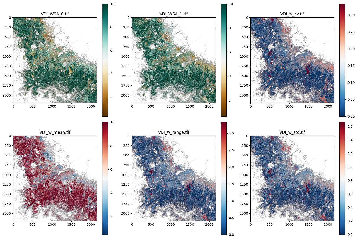
{'File': 'VDI.tif', 'Filepath': 'G:\\Data\\Thinning_Recharge_Final_Data\\SA\\resampled\\VDI.tif', 'Projection': CRS.from_wkt('PROJCS["NAD83(2011) / UTM zone 12N",GEOGCS["NAD83(2011)",DATUM["NAD83_National_Spatial_Reference_System_2011",SPHEROID["GRS 1980",6378137,298.257222101,AUTHORITY["EPSG","7019"]],AUTHORITY["EPSG","1116"]],PRIMEM["Greenwich",0,AUTHORITY["EPSG","8901"]],UNIT["degree",0.0174532925199433,AUTHORITY["EPSG","9122"]],AUTHORITY["EPSG","6318"]],PROJECTION["Transverse_Mercator"],PARAMETER["latitude_of_origin",0],PARAMETER["central_meridian",-111],PARAMETER["scale_factor",0.9996],PARAMETER["false_easting",500000],PARAMETER["false_northing",0],UNIT["metre",1,AUTHORITY["EPSG","9001"]],AXIS["Easting",EAST],AXIS["Northing",NORTH],AUTHORITY["EPSG","6341"]]'), 'Min Value': np.float32(0.3333), 'Max Value': np.float32(10.0), 'Mean Value': np.float32(7.246992), 'Extent': BoundingBox(left=445653.43769999966, bottom=3798617.068499999, right=510453.43769999966, top=3864347.068499999), 'Width': 2160, 'Height': 2191, 'Dimensions': (2191, 2160), 'Data Type': 'float32'}